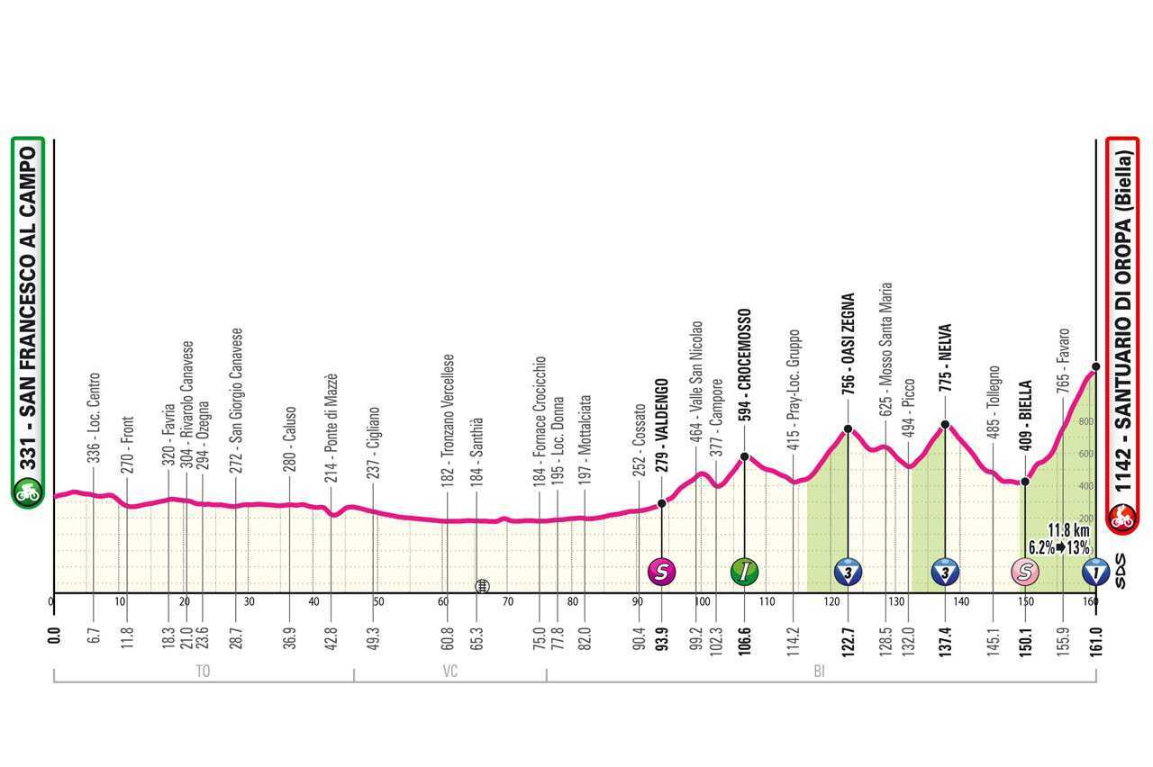
Using the latest BikeScout GPX Intelligence Tool, we processed every meter of the 155.29 km track of the Giro d'Italia 2024 Stage 2 (San Francesco al Campo - Santuario di Oropa) to decode its exact tactical requirements. Our engine transformed the raw coordinate data into high-resolution performance insights, identifying the critical vertical gain and power thresholds necessary to conquer this iconic climb.
The results confirm what we suspected: Oropa is not just a climb; it's a brutal filtration system.
Our engine identified a total ascent of 2245.6 meters, peaking at an altitude of 1136m. But the raw numbers only tell half the story. The true intelligence lies in the Climb Analysis and the Performance Simulation.
CRITICAL MISSION DATA:
- > DISTANCE: 155.29 KM
- > TOTAL GAIN: 2245.6 M
- > FINAL CLIMB (CAT 1): 14.25 KM @ 5.0%
- > PEAK GRADIENT DETECTED: 28.0%
The Anatomy of the Stage
While the stage features several Cat 3 ascents (Oasi Zegna and Nelva), the real battle was at km 140.7.
Our tool flagged the Santuario di Oropa as a 14.25 km sector with a 716m vertical gain.
Our Performance Simulation modeled a required VAM of 1350 for the leaders, translating to a staggering 6.5 Watts/kg (approx. 467.8 Watts) to stay in the Pink Jersey hunt.
Explosivity Zones: The "Road Walls"
The most fascinating discovery was the identification of "Steep Road Walls", micro-sectors with explosive gradients that don't show up in average slope data.
We detected multiple zones exceeding 25% gradient at km 97, 111, and 128.
These are the "leg-breakers" where positioning becomes the only variable that matters.
Tadej Pogačar’s attack was anticipated by our data: at km 140.7, the engine shifted from a 5.29 W/kg "cruising" simulation to a 6.5 W/kg "elite" threshold. The terrain demanded a masterpiece, and the data provided the blueprint.
Conclusion: Ground Truth over Guesswork
By fusing UCI category scoring with localized explosivity zones, we can now predict exactly where a race will break.
This level of precision is made possible by our Version 1.1.0 release, transforming raw GPX files into tactical sectors.
The Santuario di Oropa was a masterclass in effort, and our tool captured every watt of it.